


A severe weather outbreak is forecast to occur across a large area of Wisconsin on Wednesday, including most or all of the state’s largest population centers, including Milwaukee, Green Bay, Appleton, Oshkosh, Wausau, Madison, La Crosse and Eau Claire.
Here’s what’s happening:
6:18 pm: Tornado warnings for Oconto, Oconto Falls and Bonduel
As the storms move into Shawano and Oconto counties an area that includes Oconto, Oconto Falls and Bonduel has been put under a tornado warning until 6:45 pm Penny-size hail is possible, according to the National Weather Service.
6:08 pm: Tornado warnings for Waupaca, Outagamie and Shawano
The national National Weather Service Green Bay has issued a tornado warning for northeastern Waupaca County, northwestern Outagamie County and central Shawano Counties until 6:30 pm
6 pm: Tornado warnings for New London, Seymour, Hortonville, Manawa, Bear Creek, Nichols
A line of storms continue to move its way east with tornado warnings issued for New London, Seymour and Hortonville until 6:15 pm The National Weather Service in Green Bay says wind gusts in the thunderstorms will reach 80 mph. The tornado warning runs for Manawa , Bear Creek and Nichols until 6:30 pm
Line of storms with embedded tornadoes racing across Wisconsin
At 5:45 pm, a line of strong to severe storms extended from northeast of Wausau southwest to the Iowa/Wisconsin border, according to National Weather Service radar.
That line of storms is continuing to race east and is expected to hold together as it moves into an area of hot, humid unstable air in place across eastern Wisconsin.
“Numerous severe thunderstorms with embedded tornadoes are occurring along that line as it moves across the state,” said Sarah Marquardt, a National Weather Service meteorologist in Sullivan. “There have been several tornadoes and very strong straight-line winds also.
“We’re estimating winds with some of these storms are 60 to 80 mph,” she added. “Those are very, very strong straight-line winds.”
Images of storm damage from western and central Wisconsin have been posted on social media.
Marquardt said forecasters expect the storms to hold together as they approach eastern Wisconsin.
“Right now we’re watching central Wisconsin where there are numerous tornado warnings,” she said. “That line of storms is going to continue moving east through this evening.
“Everyone in eastern Wisconsin should pay attention to the weather and be prepared to take shelter as these storms approach,” Marquardt said.
A tornado watch remains in effect across all of central and eastern Wisconsin, including the Milwaukee metro area, until 10 pm
At 5:45 pm, the temperature at Milwaukee Mitchell International was a soupy 95 degrees.
“That warm humid air across southern Wisconsin and the way the winds are, it’s a very favorable environment for severe weather,” Marquardt said. “We’re expecting the line of storms to continue to move east.
“Be weather aware and ready to take cover as storms approach,” she added.
— Joe Taschler
5:43 pm: Tornado warning for Neopit, Mattoon and Bowler
The National Weather Service in Green Bay has issued a tornado warning for an area spanning Shawano and Menominee counties that includes Neopit, Mattoon and Bowler until 6 pm
5:36 pm: Tornado warning for Antigo, Deerbrook and Bryant
The National Weather Service in Green Bay has issued a tornado warning for an area that includes Antigo, Deerbrook and Bryant until 6 pm
5:23 pm: Tornado warning for Wautoma, Redgranite, Coloma
The National Weather Service in Green Bay has issued a tornado warning for an area that includes Wautoma, Redgranite and Coloma until 5:45 pm
5:10 pm: Tornado warning for Stevens Point, Wisconsin Rapids, Wausau area
A tornado warning was issued about 5 pm for parts of Wood, Portage and Marathon counties until 5:30 pm, according to the National Weather Service in Green Bay.
The warning includes Stevens Point, Wisconsin Rapids, Plover, Wausau, Weston and Rothschild.
4:59 pm: Tornado warning for Wisconsin Dells, Lake Delton area
Numerous tornado warnings are in effect in Wisconsin, including a tornado warning for northwestern Sauk County until 5:30 pm
At 4:48 pm, a severe thunderstorm capable of producing a tornado was located 10 miles northeast of Richland Center, moving northeast at 55 mph,” according to the National Weather Service. “Locations impacted include Reedsburg, Wisconsin Dells, Lake Delton, La Valle, Ironton and Lime Ridge.
— Joe Taschler
4:43 pm: Tornado warning for parts of Juneau, Adams counties
A tornado warning remains in effect until 5 pm for northwestern Juneau and northwestern Adams counties.
“At 4:29 pm, a confirmed large and extremely dangerous tornado was located 10 miles northwest of Necedah, or 14 miles northeast of Tomah, moving northeast at 30 mph,” according to the National Weather Service in La Crosse. “Damaging tornado continues. Radar indicates a continued stream of debris lofted into the air from the tornado.”
People in areas covered by the warning are in “a life-threatening situation,” the weather service said.
— Joe Taschler
4:28 pm: Tornado warnings across western, central Wisconsin
Numerous tornado warnings were in effect across western and central Wisconsin just before 4:30 pm, according to the National Weather Service.
At 4:22 pm, NWS confirmed a large and extremely dangerous tornado 11 miles northeast of Tomah, moving northeast at 40 mph.
“This is a particularly dangerous situation,” according to the weather service office in La Crosse. “Take cover now!”
— Joe Taschler
4:10 pm: Tornado reported near Tomah
A tornado warning is in effect until 5 pm for Juneau, Adams and Monroe counties.
“At 4:02 pm, a confirmed tornado was located near Tomah, moving northeast at 40 mph,” according to a statement from the National Weather Service in La Crosse. “The tornado will be near Necedah around 4:30 pm,” according to the statement.
The weather service said the tornado has been confirmed by radar and weather spotter.
— Joe Taschler
2:35 pm: Tornado watch issued; includes Milwaukee metro area, Green Bay, Wausau, La Crosse
The National Weather Service has issued a tornado watch for a large portion of central and southern Wisconsin until 10 pm
Some of the cities covered by the tornado watch include Milwaukee, Waukesha, Appleton, Oshkosh, Green Bay, Sheboygan, Fond du Lac, Madison, Wausau, Wisconsin Rapids, Stevens Point, Marshfield, Manitowoc, Janesville, La Crosse, Wisconsin Dells, Sturgeon Bay and Rhinelander. It also encompasses the following counties:
Adams, Brown, Calumet, Clark, Columbia, Crawford, Dane, Dodge, Door, Florence, Fond du Lafc, Forest, Grant, Green, Green Lake, Iowa, Jackson, Jefferson, Juneau, Kewaunee, LaFayette, Langlade, La Cross, Lincoln, Manitowoc, Marathon, Marinette, Marquette, Menominee, Milwaukee, Monroe, Oconto, Oneida, Outagamie, Ozaukee, Portage, Richland, Rock, Sauk, Shawano, Sheboygan, Taylor, Trempeleau, Vernon, Vilas, Washington, Waukesha, Waupaca, Waushara, Winnebago and Wood.
— Joe Taschler
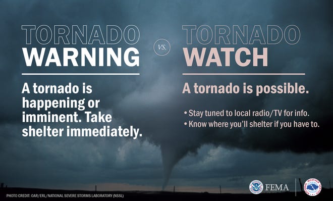
2:45 pm: The difference between a tornado watch and a tornado warning
A tornado watch defines a cluster of counties where tornadoes and other kinds of severe weather are possible in the next several hours. It does not mean tornadoes are imminent, just that you need to be alert, and to be prepared to go to safe shelter if tornadoes do happen or a warning is issued.
A tornado warning means that a tornado has been spotted, or that National Weather Service Doppler radar has detected a thunderstorm circulation which can spawn a tornado. “When a tornado warning is issued for your town or county, take immediate safety precautions,” according to the Storm Prediction Center.
— Joe Taschler
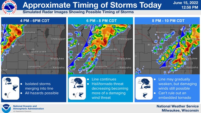
2:13 pm: Potential storm timing for southern Wisconsin
Forecasters expect severe storms to occur during the mid- to late-afternoon hours and continue into the evening. Storms are expected to move west-to-east across the region. Storms could weaken by the time they reach Milwaukee, “but no one in Milwaukee should let their guard down,” said Mark Gehring, a National Weather Service meteorologist.
Here’s a look at how forecasters expect the storms to evolve. The radar images are simulated.
— Joe Taschler
1:39 pm: Heat advisory remains in effect for Milwaukee area, Sheboygan, Fond du Lac
A heat advisory remains in effect until 8 pm on Wednesday for Fond du Lac, Sheboygan, Dodge, Washington, Ozaukee, Iowa, Dane, Jefferson, Waukesha, Milwaukee, Lafayette, Green, Rock, Walworth, Racine and Kenosha counties.
Heat index values — what the combination of temperature and humidity makes it feel like outside — are expected to reach as high as 102 degrees on Wednesday in those counties.
— Joe Taschler
1:31 pm: Two ‘probable’ heat-related deaths in Milwaukee
The Milwaukee County Medical Examiner’s Office is investigating two “probable” cases of heat-related deaths Wednesday.
Brian Peterson, the chief medical examiner, said the victims are a 39-year-old Milwaukee female and an 89-year-old Greenfield male. Both were pronounced dead Wednesday morning, according to the office’s online records.
Autopsies are scheduled for Thursday, Peterson said.
Milwaukee County and much of southeastern Wisconsin is under a heat advisory until 8 pm Wednesday, according to the National Weather Service in Milwaukee. Heat index values are expected to reach as high as 102 degrees.
— Eliot Hughes
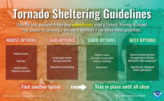
1:26 pm: Campers need to be alert
Forecasters are urging anyone who is camping anywhere in Wisconsin on Wednesday to have a plan to seek shelter if severe storms approach.
Tents and campers provide very little protection against severe thunderstorm winds and tornadoes, weather service forecasters said.
Here are some recommendations for seeking shelter should the need arise.
— Joe Taschler
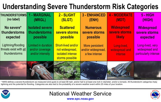
12:17 pm: Storm center upgrades risk for Wisconsin
The national Storm Prediction Center has placed a large portion of the state in a moderate — level 4 out of 5 — risk for severe storms.
While not necessarily rare, such a risk level is uncommon for Wisconsin, said Ben Miller, a meteorologist with the National Weather Service in Sullivan.
Almost the entire state on either side of a diagonal line from La Crosse to Green Bay is under a risk for severe storms, according to the Storm Prediction Center.
Here’s where forecasters think the worst of the storms will occur:
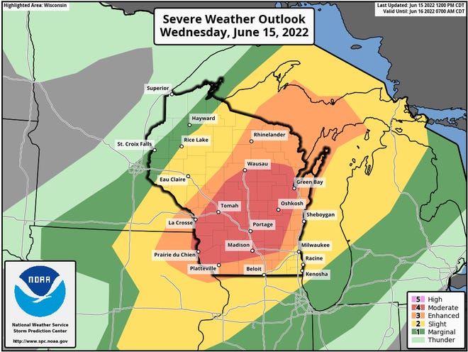
Here’s how those risk areas are categorized:


Comments are closed.