

Forecasters say parts of southern Wisconsin could see heavy rain late Saturday night and continuing into Sunday.
But before any rain comes, things outside will be downright uncomfortable.
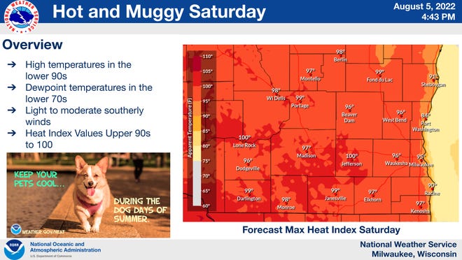
The heat index – what it actually feels like outside when warm temperatures and high humidity are combined – could reach 95 to 100 degrees on Saturday across southern Wisconsin, including the Milwaukee metro area.
Areas right along the Lake Michigan shoreline might be slightly cooler.
“The biggest issue on Saturday is going to be the humidity,” said Denny VanCleve, a meteorologist with the National Weather Service in Sullivan. “It’s going to be sticky.”
“Drink plenty of water and stay in the shade, if you can,” he said.
The warm and sticky airmass prompted the Wisconsin Department of Natural Resources to issue an air quality advisory for Saturday. The advisory kicks in at noon and runs through Saturday night. Counties included in the advisory are Milwaukee, Waukesha, Ozaukee, Washington, Brown, Calumet, Door, Fond du Lac, Kenosha, Kewaunee, Manitowoc, Racine, Sheboygan and Walworth.
The agency says it expects the air to be “unhealthy for sensitive groups” including people with lung ailments, children and older adults.

All the moisture in the air is going to likely kick off rain showers and thunderstorms by late Saturday night continuing into Sunday. “With that much moisture, rainfall rates could be very high,” VanCleve said.
Forecasters are also concerned about the potential for thunderstorms to repeatedly move across the same areas late Saturday and Sunday.
Some strong storms could occur late Saturday night, “but our main concern right now is the heavy rainfall potential,” VanCleve said.
Forecasters will be working during the next 24 hours to fine-tune where they think the heaviest rain will fall.
“We’ll be keeping an eye on it,” VanCleve said.
Comments are closed.